send link to app

London - Offline Maps & city guide (w/ metro!) app for iPhone and iPad


4.8 ( 8288 ratings )
Travel Navigation
Developer: Ignacio Z.
Free
Current version: 6.02, last update: 7 years ago
First release : 29 Aug 2010
App size: 62.51 Mb

London Offline Maps

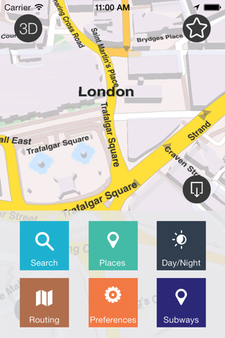
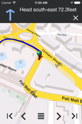
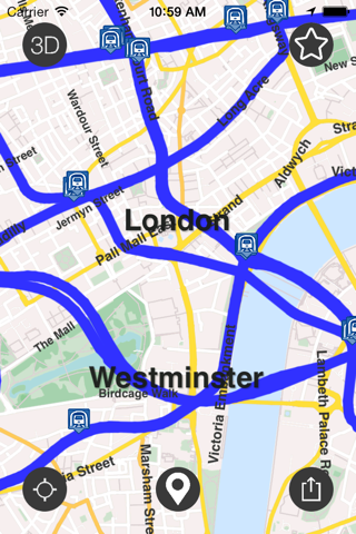
This application provides you with offline maps for LONDON with features such as searching and ROUTING without the need of an internet connection

Note: this version is working with ios 6.0 and upwards. A new version is being finalized that will support ios5.0

Why Offline maps?
It allows you to extend your battery life and lets you save from paying expensive roaming charges when traveling.

Why TRUE offline maps? Because it is the only application for the iphone that will allow you to have

+offline routing for any place you download. It doesnt preload routes, but calculates them without the need to be connected to the internet.
+offline places of interest (POI) for any part of the world. You dont need to buy additional packages to get POI, everything is there when you download it.
+offline search: search for street names and places (house numbers coming soon).

Pros and cons of London - Offline Maps & city guide (w/ metro!) app for iPhone and iPad

London - Offline Maps & city guide (w/ metro!) app good for

From Paris I often go to London and I enjoy with my young daughter this app !
This App gives an excellent support for anyone travelling to London. Sometimes the map fulfill the screen with too many yellow lines on it but its a small bug that can be easily solved closing the app snd then reopening it!!!!
Double tap function for start and end of route saves a lot of typing and the route line is perfect. Great offline product-London map
It is so perfect having these maps on my ipod touch. No need for a wi-fi connection or data on my phone
Smaller than an A to Z. Great if you cant get good data plans while travelling & you want to wander without getting completely lost.
Very nice app! It works perfectly and its free! Just a suggestion to the authors, it would be useful displaying the total distance with the estimated time, in order to give an additional info o travellers.

Some bad moments

The same map was great around 4 month ago! The new design looks quite unprofessional, the menu isnt user friendly - too dark, mistakes like piccadillv lane confirm my crit! Please upload the old map again or copy google maps!
Nice enough, but two major problems: 1. Hundreds of streets are just not named. 2. The river, the very object of orientation, is not blue. This is unusual, to say the least. On the plus side, there is a nice feature with the tube: Hit a button, and all tube lines appear ON THE STREET MAP. No stop names, but nice yet.
Not do great. Does not even have the Tower of London on it anywhere. Considering this is a major Tourist site, you would thing it would. Also, lots of the Underground station are missing. Very disappointed.
It crashes on my iPad with iOS6 shortly after launching. I deleted it 1 minute after trying it - it simply doesnt work.
It would be nice if instead of telling you it does a lot ot things they just told that for the most of them you need to upgrade to the premium version.
Current version (downloaded today) is very slow and crashes continously in my iPad version 1. If my iPad was not suitable, than it should be avoided to allow to download it.